
|
|
| 3.5.3 |
Salinity of Estuaries |
| One consistent feature in estuaries is their fluctuation in salinity. During high tide or drier seasons, such as the summer in North America, an estuary will have more salt water and increased evaporation, and therefore higher salinity. During low tide or when river runoff levels are high due to rain or snow melt, estuaries will have more freshwater and therefore lower salinity. These cycles vary daily with the tides and seasonally with the weather. The degree to which salt and fresh water mix can depend on the geology of the estuary. Some estuaries are stratified with the dense salt water on the bottom and freshwater on the surface. Others mix the two waters rather uniformly. The area where the salinity changes can be called a halocline. Estuary circulation is classified as: |
| Salt Wedge estuaries have a distinct pattern of salt water at the bottom and fresh water at the surface due to the differences in density of the water. An angular halocline forms between the fresh and salt water with a distinct difference in the salinities of each layer. Estuaries with large amounts of freshwater and lower tidal currents tend to form salt wedges. The Columbia River, between Oregon and Washington in the United States, typically shows this pattern of mixing. |
| Partially Mixed estuaries have mixed salinity at all depths but the deeper water is saltier than water at the surface. The gradient of salinity is slightly angled with the highest salinity near the ocean and at depth for a distance inland with a steady decrease in salinity to the freshwater source. Puget Sound in Washington State demonstrates partially mixed circulation. |
| Mixed or Vertically Mixed estuaries occur in shallow estuaries when tidal influences are significant and the amount of freshwater entering the estuary is relatively low. The force of the tide mixes the water evenly from the surface to the bottom. Water closest to the ocean has the highest salinity. Salinity amounts decrease steadily to almost zero at the river mouth. |
|
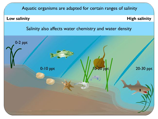
In a mixed estuary, salinity changes from top to bottom in a series of columns with higher salinity near the ocean. Organisms in estuaries are adapted for a range of salinity. They may migrate to stay in areas of high or low salinity or osmoconform to changes that occur throughout the day. Image from https://coast.noaa.gov/estuaries/science-data/ |
(Revised 10 August 2018) |