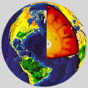
 (LJF adapted from NASA image) (LJF adapted from NASA image) | Four distinct layers make up our planet Earth according to geologists. The central, inner core is the hottest, most dense, and probably solid. The next layer, or outer core, is still very hot. The mantle is the layer that gets increasingly cooler as you move toward the surface but is still molten under the outermost layer called the crust. The crust is the outer solid part of our planet averaging 8–32 km in thickness.
1. Inner Core: 2,456 km diameter (1,228 km radius), composed primarily of high density, solid nickel
and iron.
2. Outer Core: 2,260 km thick, composed of molten nickel and iron.
3. Mantle: 2,890 km thick, composed of silicates and therefore less dense than the nickel/iron core.
4. Crust: 8–32 km thick (exaggerated here). If the 12,756 km diameter of Earth were shrunk to 12 inches, the crust would be less than the thickness of 4 sheets of paper. |
 (LJF image) (LJF image) |
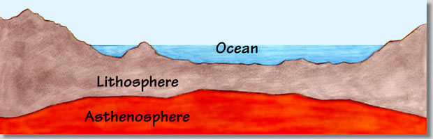
Earth's crust "floats" on the hot, molten layer of the mantle. This molten layer is a dense "magma" that supports the lighter crust. The crust has different thicknesses and composition depending on where it is located. Some of the crust is mostly terrestrial (forming the continents), but much of it is marine (underlying the bottoms of the oceans).
The rigid material that floats on Earth's surface is termed the lithosphere. The low velocity plastic layer (molten magma) under the lithosphere is called the asthenosphere. It is believed that heat induced convection currents in the asthenosphere move (or float) the lithosphere. |
 (LJF image) (LJF image) |
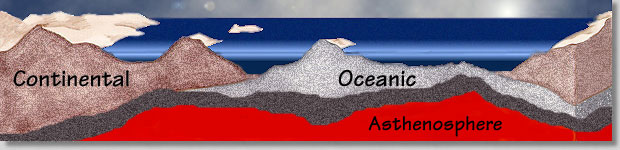
The lithosphere is subdivided into outer rock material that forms the thin outer crust over continents and ocean bottoms (brown and light gray) and a transition zone (solid gray) between the crust and the asthenosphere. The asthenosphere is a subdivision of the mantle that is below the lithosphere and may be 100 to 700 kilometers below the surface. |
 (LJF image) (LJF image) |
There are many rock types that comprise Earth's surface; however, they can all be classed as either oceanic or continental in origin. Andesitic material (a mixture of oceanic and continental crust) is also found in a few unique areas.
Oceanic crust is more dense than continental crust. Oceanic crust is the main crustal unit under Earth's oceans. It is often called basalt. Oceanic crust has lots of silica and iron and may be referred to as simatic. It is generally not much more than 7 km thick. Undersea volcanos composed of oceanic crust may form undersea mountain ranges or oceanic islands (like Iceland, Hawaii, or Galapagos).
Continental crust generally "rests" on top of oceanic crust and is often called granitic. It is the main crustal unit forming Earth's major continental land masses and a few continental islands (like Greenland, Madagascar, and California's Channel Islands). Continental crust has lots of silica and aluminum and may be referred to as sialic. Its thickness varies from only a few km at the edges of continents to over 32 km in the middle of continents. |
 (LJF image) (LJF image) |
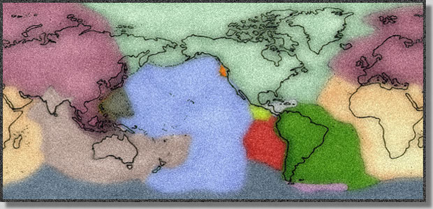
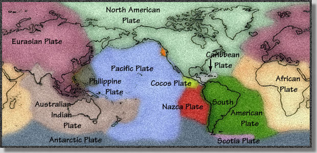
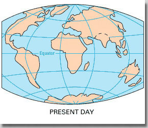
Earth's crust not only moves on top of the hot molten layer but is broken into pieces that move relative to each other. These pieces are called "plates" and their relative movement can be used to explain many of Earth's geological features (mountain ranges, trenches).
Earth's twelve major plates are diagrammed here (above and below). Some are oceanic crust and some are oceanic crust with continental crust.
|  (LJF image) (LJF image) |
 (LJF adapted from USGS image) (LJF adapted from USGS image)
|
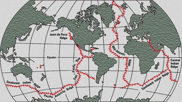
Oceanic ridges/rises on Earth run around the globe like the seams on a baseball diagrammed above in red. Plates are moving apart at oceanic ridges/rises creating undersea volcanos that build an undersea mountain range. This undersea mountain range stretches all around Earth. It runs right down the middle of the Atlantic Ocean where it is called the Mid-Atlantic Ridge. The part of this undersea mountain range that runs up the Pacific Ocean in the southern hemisphere, just east of the Central Pacific, and up to the Gulf of California is called the East Pacific Rise. |
 (LJF image) (LJF image) |
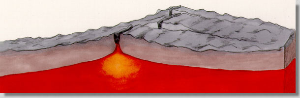
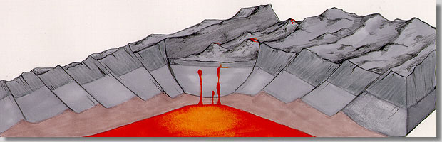
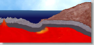
A cross-section of an oceanic ridge/rise shows its general features (above). Oceanic ridges/rises are called spreading centers because this is where two plates are moving apart. It is an area of plate divergence where new crust is added to the diverging plate edges.
There is often a central rift valley in the area where much of the volcanism occurs. Most areas have many transform faults that offset the rift valleys and make breaks in the oceanic ridge/rise system perpendicular to the axis of the rift valleys. The mountains on either side of the rift valley are mirror images, getting older as you go away from the rift valley. |
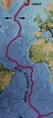 |
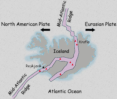
Iceland, "the land of fire and ice", is being split by an oceanic ridge that surfaces to create an oceanic island (left and below) in the North Atlantic Ocean. Red triangles show Iceland's active volcanos, including Krafla. Reykjavik is Iceland's capital.
 (LJF image) (LJF image) |
|

 (LJF image)
 (LJF image)
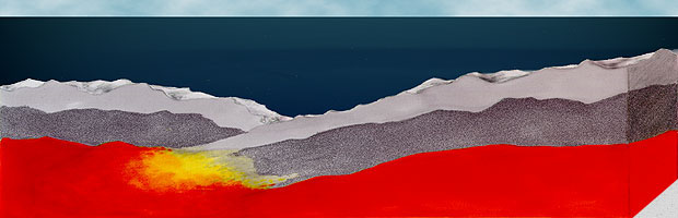 (LJF image)
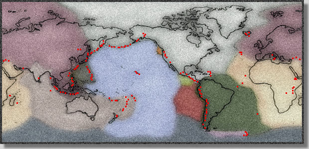 (LJF image)
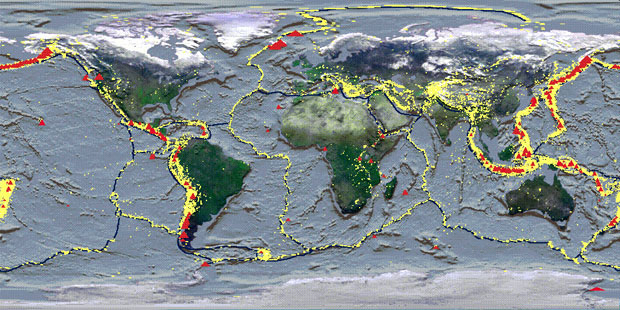 (LJF adapted from NASA image)
 (LJF adapted from NASA image)
 (LJF image)
 (LJF image)
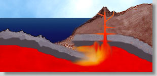 (LJF image)
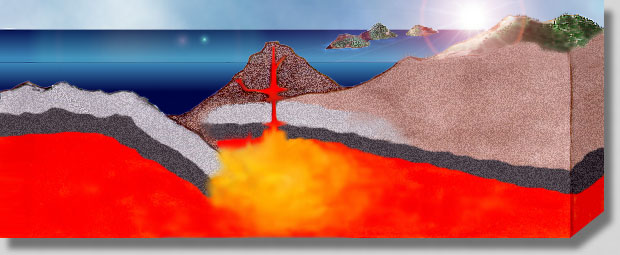 (LJF image)
 (NASA image)
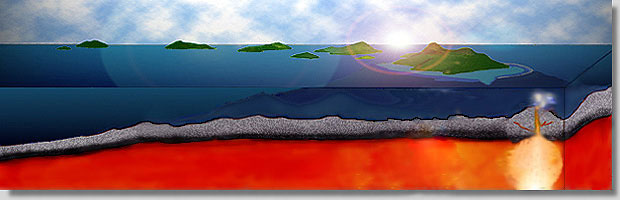 (LJF image)