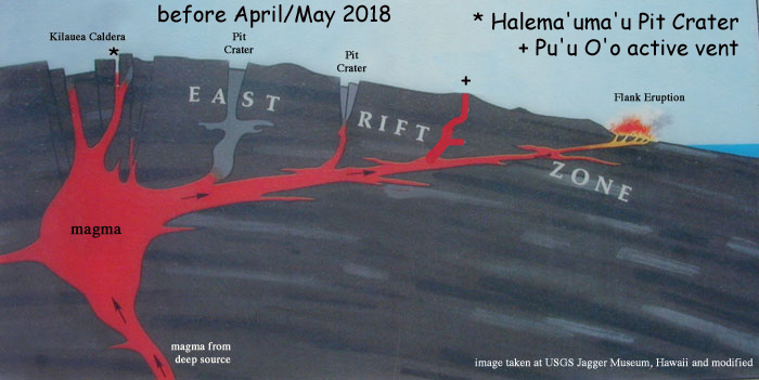
| This repeated and edited image from the Jagger Museum shows what was thought to be the state of the east rift zone until April/May, 2018. Starting in April/May 2018 at the summit of Kilauea Caldera the lava lake inside Halema'uma'u (*) drained down, Pu'u O'o (+) 10 miles away drained and collapsed and there was increased seismicity in the lower part of the east rift zone. On May 3, 2018 fissures (24 as of July 14, 2018) began opening and oozing lava in this lower part of the east rift zone as a major flank eruption. |
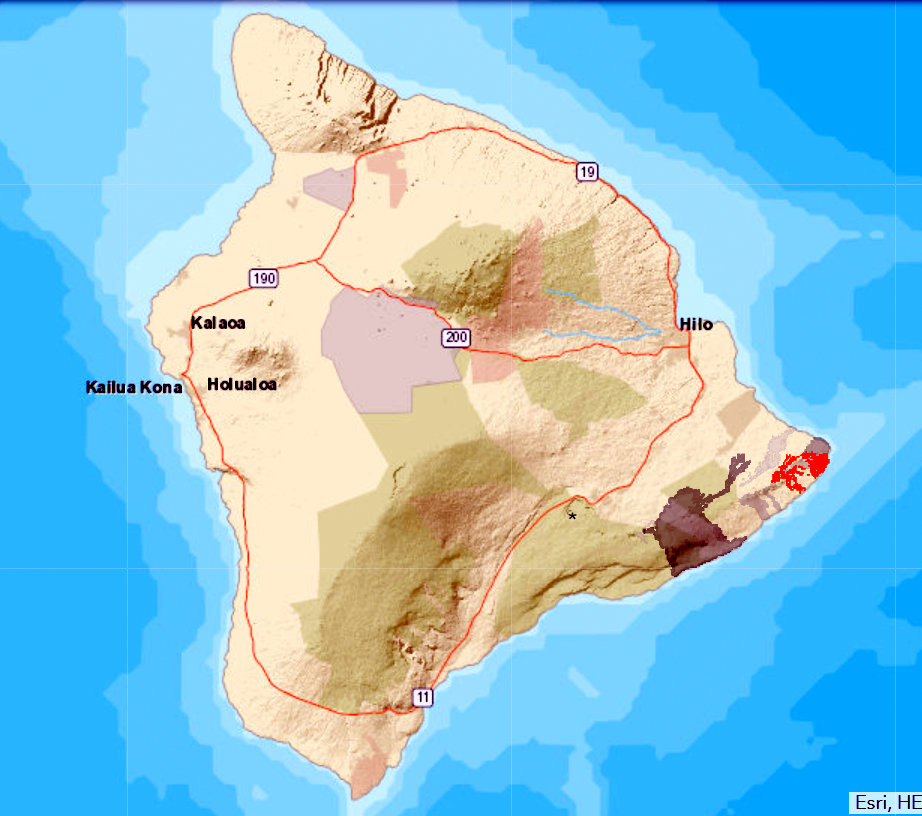
Hawaii Island showing Pu'u O'o lava flows (gray) and 2018 flank eruptions (red). (USGS image).| This July 13, 2018 image from the USGS shows the location of Halema'uma'u (*), previous Pu'u O'o lava flows (dark gray) and the new 2018 flank eruption flows (red). |
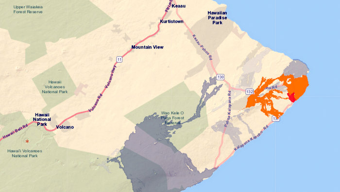
Old flank eruptions from Pu'u O'o lava flows (gray) and new 2018 eruptions (red). (USGS image).| The 24 fissures opened and released varying amounts of gas and lava starting on May 3, 2018. Fissure 8 was the most active and continued to release large amounts of lava. The lava flowed in a perched lava channel (70 or so feet high) to the ocean, creating new land while destroying over 700 homes as of July 13, 2018 with no end in sight. |
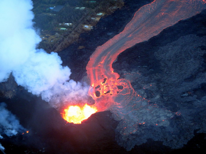
Fissure 8 on June 7, 2018 (GA image)| On June 7, 2018 a 'doors off' helicopter ride to the east rift zone revealed the state of the eruption. Fissure 8 had a cone averaging about 200 feet high and continued to release lava that was channeled in a perched lava channel to the ocean some 7-8 miles away. |
Fissure 8 and lava channel on June 7, 2018 (GA image)| The lava channel is maintained by sides (levees) of cooled lava (black - 70 feet high) (thus it is called a 'perched' lava channel). Breakouts occurred along the channel but were generally short lived. Under this lava was a once thriving community called Leilani Estates and Lanipuna Gardens. |
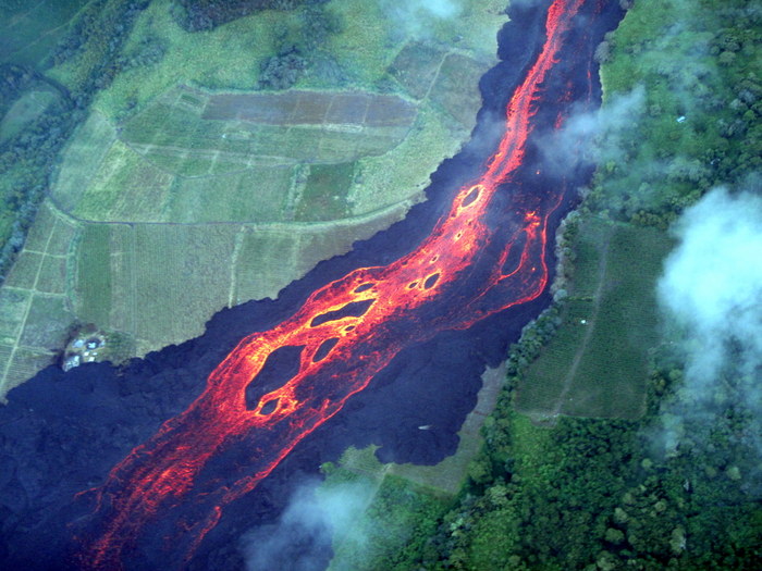
Braided River Channel with Kipukas on June 7, 2018 (GA image)| The braided river channels running to the ocean left periodic kipukas (areas not covered by lava) surrounded by lava. Not only were communities buried by this flow but acres of fields, as seen here. |
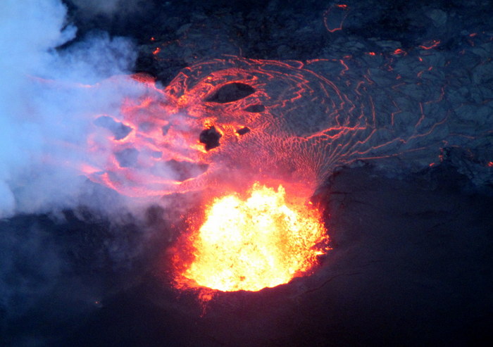
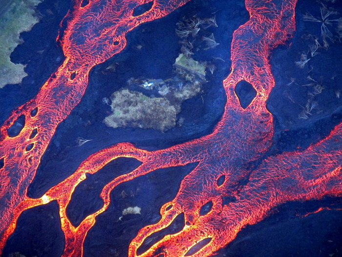
Kipuka and Crusted Lava (GA image)| This close up shows a lone dwelling in a kipuka but no way to access it. The surface of the flowing lava crusts (black) if it cools. When the entire surface cools, and the lava is still flowing beneath it, a 'lava tube' is formed. |
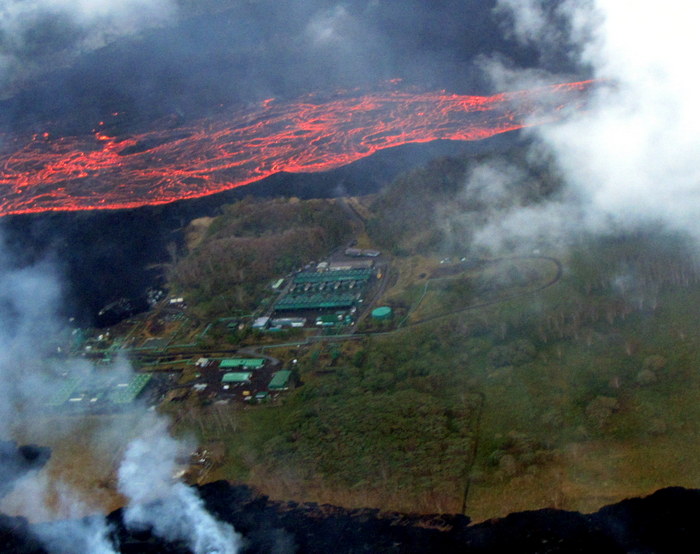
Puna Geothermal Plant in a Kipuka (GA image)| Puna Geothermal Plant removed all the hazardous materials and capped its wells before the flow got to it. The flow only covered two of the wells but the plant will most probably never reopen. |
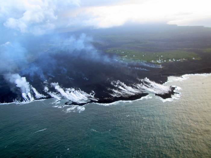
Ocean Entry at Kapoho on June 7, 2018 (GA image)| The major ocean entry at the end of the 7 miles of perched lava channel was at Kapoho. It consumed Kapoho Bay and the Kapoho Tidepools, Wai'opae Marine Preserve (a favorite snorkeling spot), along with homes, parks and other infrastructure. Over 700 acres of new land had been formed, as of July 2018, along this southeast coastline. The lava channel had crusted over at the ocean entry with the flowing lava getting to the ocean through lava tubes. As of July 14, 2018 there was no end in sight. |
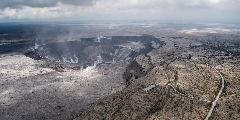
June 18, 2018 Halema'uma'u (USGS image)| As Fissure 8 continued to be the most active area of Kilauea Volcano, the summit of the volcano underwent incredible transformations. The floor of Kilauea Caldera continued to subside as the magma chamber under Halema'uam'u drained which caused Halema'uma'u to cave in on itself. As its sides caved in they plugged up the vent and huge explosions began to occur almost every day with a magnitude 5.3 (or so). The explosions were near the surface and posed no tsunami threat but they did produce ash which fell nearby and could damage infrastructure. Hawaii Volcanoes National Park remained closed.This image shows how much Halema'uma'u has increased in size (4 times) and the cracks it has produced in the area of the Jagger Museum and USGS Hawaiian Volcano Observatory (seen here as the buildings in the right center of the image). Both the Museum and USGS Hawaiian Volcano Observatory may never be safe again. Displays from the Museum were moved and the scientists from the USGS Hawaiian Volcano Observatory relocated to Hilo. |
| Almost as suddenly as the 2018 Lower East Rift Zone eruption started, it slowed down in early August 2018. Fissure 8 stopped fountaining and drained down to a small pool of lava in the bottom of its 200 foot high cone, mostly crusted over. The perched lava channel crusted over. Only a few small areas of ocean entry (from lava tubes) at Kapoho were left. The USGS and National Park folks are not sure if this is the end or if this eruption event will start back up at any day. |
| Both the Hawaii Volcanoes National Park and the United States Geological Survey (USGS) have images that they make available to the general public illustrating Hawaiian volcanic activity. Below are a selected few historical images to show the active volcanism in Hawaii. |
Halema'uma'u Crater in Kilauea Volcano.Hawaii Volcanoes National Park image
Eruptions of Kilauea
Halema'uma'u Crater
November 1967
During the eruption the view at night was spectacular. |
Northeast Rift of Mauna Loa Volcano.Hawaii Volcanoes National Park image
Kilauea and Mauna Loa
Northeast Rift 9,400 feet
Mauna Loa
March 30, 1984
Fountains of lava are unusual in Hawaii but they do occur during major eruptions. |
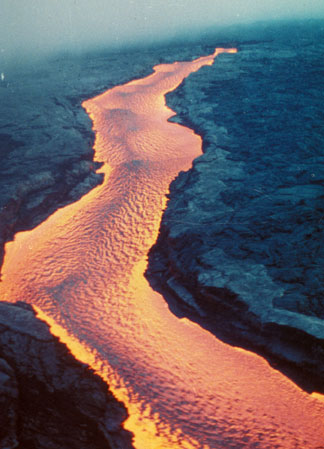
Mauna Loa Lava River.Hawaii Volcanoes National Park image
Kilauea and Mauna Loa
Mauna Loa Lava River
March 30, 1984
The hot river of lava is just starting to cool on the surface as it flows downhill. |
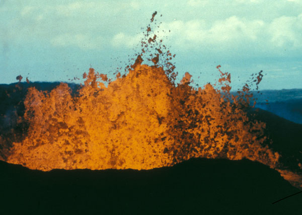
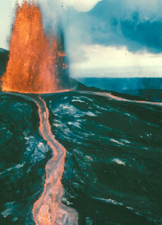
Fountain and Lava Channel.Hawaii Volcanoes National Park (USGS image)
Kilauea Pu'u O'o Eruption
Vigorous Fountain and Lava Channel
June 2, 1986
Puu Oo vent calmed down considerably since this event, continued to produce flows that created ocean entires, covered east rift zone communities and threatened towns for 35 years. Then, on April 30, 2018 the floor of the crater collapsed leaving a gaping deep hole and the magma underneath it moved along the rift zone toward Kapoho. |
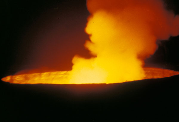
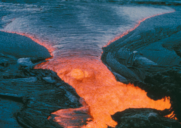
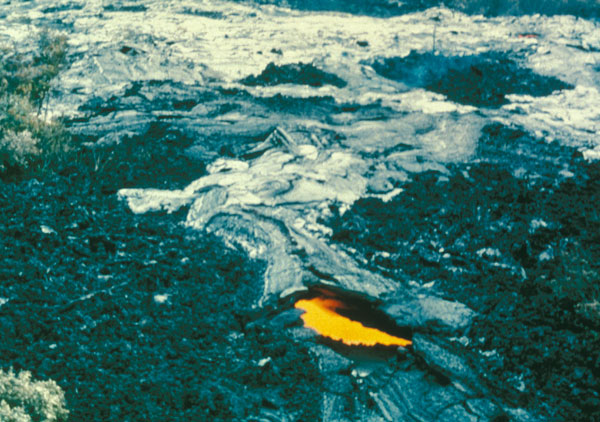
Lava Pond.Hawaii Volcanoes National Park (USGS image)
Kilauea Pu'u O'o Eruption
Lava Pond at Summit of Shield C-48
Notice how the top of the lava pond has started to cool and is forming a crust. |
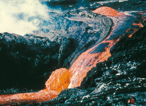
Lava Flow.Hawaii Volcanoes National Park (USGS image)
Kilauea Pu'u O'o Eruption
Lava Welling from Opening in Tube
December 16, 1986 |
Skylight.Hawaii Volcanoes National Park (USGS image)
Kilauea Pu'u O'o Eruption
Skylight in Active Lava Tube
December 19, 1986
If the molten lava in the lava tube flows through and leaves it empty, this skylight will provide access to this tube when it cools. |
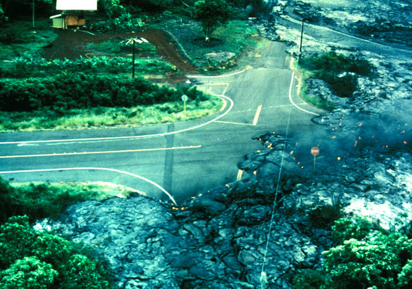
Kalapana Gardens Lava Flow.Hawaii Volcanoes National Park
Kilauea Pu'u O'o Eruption
Pahoehoe Flow at Kalapana Gardens
December 1986
This lava flow covered an entire community (destroying 180 homes) at Kalapana Gardens on its way to the south shore of Hawaii where it covered popular beaches and created new acreage of lava shelves. |
|
|
|
|
|
|
|
|
|
|
|